
Contact Seller
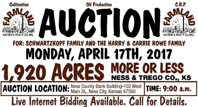

Auction: 1920 Acres +/- Ness & Trego Counties, Kansas
Description
For: Schwartzkopf Family And The Harry & Carrie Rowe Family
Date: Monday, April 17th, 2017
Time: 9:00 A.M.
Auction Location: Ness County Bank Building-102 West Main St., Ness City, Kansas 67560
Tract I
Legal Description
Northeast Quarter (NE/4) of Section Thirty-Four (34) Township Eighteen (18) South, Range Twenty-Four (24) West of the 6th P.M. Ness Co., Kansas (surface rights only)
F.S.A. Information
153.21 Acres Cultivation (milo stalks) 3.27 Acres Grass Waterway & Lease Roads Wheat Base 80.6 Acres PLC 43 bu. ARC Grain Sorghum 76.04 Acres PLC 61 bu. PLC
General Information
Soils consists of over 122 Acres of Harney, Uly & Roxbury Silt Loam Soils of 1-3% Slopes. 2016 Taxes were $871.02
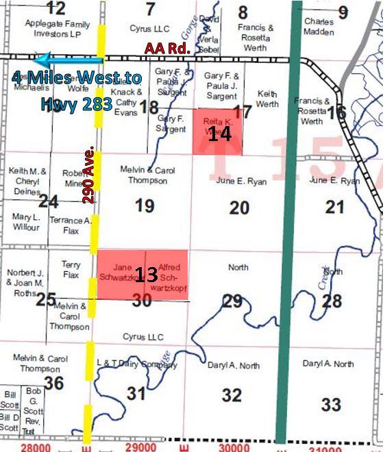
Tract II
Producing Royalty Interest (.125) on Tract I
Legal Description
Northeast Quarter (NE/4) of Section Thirty-Four (34) Township Eighteen (18) South, Range Twenty-Four (24) West of the 6th P.M. Ness Co., Kansas
General Information
This tract contains 3 producing oil wells last well put on pump in January of 2017. Owner’s oil check for February 2017 was $6,423.76. Check for March 2017 was $4,770.07. First well produced in May of 2012. Total production for 2016 was 3,221 bbls. Total production for 2015 was 4,997 bbls. Effective date of transfer is July 1st, 2017. Producing Zone: Mississippi
Tract III
Combination of Tracts I & II. Will sell in the highest aggregate bid.
Tract IV
Legal Description
Southwest Quarter (SW/4) of Section One (1) Township Nineteen (19) South, Range Twenty-Four (24) West of the 6th P.M. Ness Co., Kansas
F.S.A. Information
157.58 Acres Cultivation (Wheat Stubble) Wheat Base 81.1 Acres PLC 43 bu. ARC
Grain Sorghum 76.48 Acres PLC 61 bu. PLC
General Information
Soils consists of 136 acres of Harney Silt Loam of 0-1% slopes & 22 acres of Coly- Uly Silt Loam soil. There is one older water well on the East side of the property. 2016 Taxes were $954.60. Chemical & Application Fee: $4,261.12
Tract V
Legal Description
Southwest Quarter (SW/4) of Section Thirty-Five (35) Township Eighteen (18) South, Range Twenty-Four (24) West of the 6th P.M. Ness Co., Kansas
F.S.A. Information
157.54 Acres Cultivation (Milo Stalks) 1.18 Acre Grass Waterway Wheat Base 61.92 Acres PLC 50 bu. PLC Grain Sorghum 61.78 Acres PLC 66 bu. PLC
Oil Production
This Tract contains 1 producing oil well with a total production from 1-01-16 through 11-30-16 of 2,445 bbls, total production for 2015 was 4,441 bbls. Seller conveying a 0.125 royalty interest to the purchaser. Effective date of transfer July 1, 2017 oil well first produced September of 2014. Producing Zone: Mississippi
General Information
Soils Consist of 123 Acres of Harney Silt loam of 0-1% slopes, 28 Acres of Harney & Uly Silt loam of 1-3% slopes, and 7 acres of Coly-Uly Silt Loam. 2016 Taxes were $983.90
Tract VI
Legal Description
Southeast Quarter (SE/4) of Section Thirty-Five (35) Township Eighteen (18) South, Range Twenty-Four (24) West of the 6th P.M. Ness Co., Kansas (surface rights only)
F.S.A. Information
159.61 Acres Cultivation (Planted Wheat)
0.5 Acres Lease Roads Wheat Base 80.89 Acres PLC 43 bu. ARC Grain Sorghum 76.25 Acres PLC 61 bu. PLC
General Information Soils consist of 150 Acres of Harney, Wakeen, Hord & Uly Silt Loam Soils 0-3% Slopes. 2016 Taxes were $742.22
Tract VII
Producing Royalty Interest (.125) on Tract VI
Legal Description
Southeast Quarter (SE/4) of Section Thirty-Five (35) Township Eighteen (18) South, Range Twenty-Four (24) West of the 6th P.M. Ness Co., Kansas
General Information
This tract contains 2 producing oil wells with a total production from 1-01-16 through 11-30-16 of approx. 1,228 bbls. Total production for 2015 approx. 1,588 bbls. Seller conveying a 0.125 royalty interest to the purchaser. Effective date of transfer July 1, 2017. Oil well first produced February 1985. Producing Zone: Mississippi
Tract VIII
Legal Description
Southwest Quarter (SW/4) of Section Thirty-Six (36) Township Eighteen (18) South, Range Twenty-Four (24) West of the 6th P.M. Ness Co., Kansas (surface rights only)
F.S.A. Information
156.62 Acres C.R.P. @ $35.59/acre 10-01-11 through 09-30-21. Annual Payment: $5,573.00 1.72 Acres Oil Lease Roads & Tank Battery Site
General Information
Excellent Hunting potential for both deer & upland bird hunting, property has 2 wild life guzzlers. The property is terraced and contains 128 acres of Wakeen, Harney, Uly, Hord & Bridgeport Silt Loam Soils of 0-3% Slopes. 2016 Taxes were $459.20
Tract IX
Producing Royalty Interest (.125) on Tract VIII
Legal Description
Southwest Quarter (SW/4) of Section Thirty-Six (36) Township Eighteen (18) South, Range Twenty-Four (24) West of the 6th P.M. Ness Co., Kansas
General Information
This tract contains 2 producing oil wells. Production from 1-1-16 through 11-30-16 of approximately 967 bbls. Total production for 2015 approx. 1,152 bbls. Seller conveying a 0.125 royalty interest to the purchaser. Effective date of transfer July 1, 2017. First produced in 1985. Producing Zone: Mississippi
Tract X
Legal Description
Southwest Quarter of Section Ten (10) Township Nineteen (19) South, Range Twenty-Four (24) West of the 6th P.M. Ness Co., Kansas
F.S.A. Information
131.45 Acres Cultivation (wheat stubble) 28.76 Acres grass & grass waterway
Wheat Base 69.93 Acres PLC 43 bu. ARC Grain Sorghum 65.94 Acres PLC 61 bu. PLC
General Information
There is approx. 100 acres of Harney Silt Loam Soil 0-1% slope. In the grass area there have been food plots planted in several areas to improve the hunting habitat, there is seasonal water. 2016 Taxes were $754.72. Chemical & Application Fee: $3,027.17
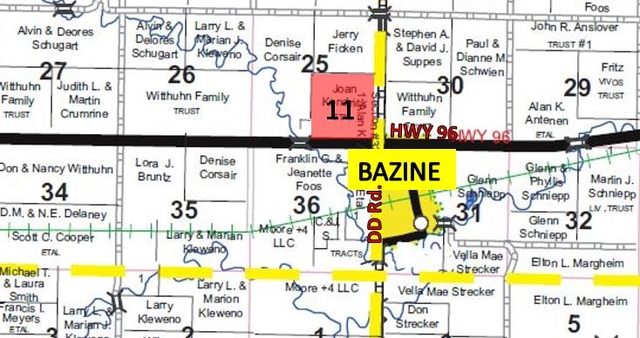
Tract XI
Legal Description
Southeast Quarter (SE/4) of Section Twenty-Five (25) Township Eighteen (18) South, Range Twenty-Two (22) West of the 6th P.M. Ness Co., Kansas (except a 5.27 acre tract located in the SEC)
F.S.A. Information 150.43 Acres Cultivation (milo stalks) Wheat Base 77.48 Acres PLC 43 bu. ARC Grain Sorghum Base 72.95 Acres PLC 61 bu. PLC
General Information
This tract adjoins Bazine, Ks on the NW Corner and has Highway 96 Frontage. Soils consists of 150 Acres of Harney Silt Loam Soil with majority of slopes 0-1%. 2016 Taxes were $903.94
Tract XII
Legal Description
West Half (W/2) of Section Thirty-Three (33) Township Twenty (20) South, Range Twenty-One (21) West of the 6th P.M. Ness Co., Kansas
F.S.A. Information
133.67 Acres Cultivation (all in planted wheat) 182.1 Acres C.R.P. @ $34.83/acre 10-01-11 through 9-30-26. Annual Payment: $6,343.00
General Information
The cultivation contains all Harney Silt Loam Soils of 0-3% Slopes. 2016 Taxes were $1,421.40
Tract XIII
Legal Description
North Half (N/2) of Section Thirty (30) Township Fifteen (15) South, Range Twenty-Two (22) West of the 6th P.M. Trego Co. Kansas
F.S.A. Information
234.38 Acres Cultivation (104.4 acres planted to wheat)
Wheat Base 136.99 acres PLC 43 bu. ARC
Grass Sorghum 128.98 acres PLC 61 bu. PLC 86.8 Acres C.R.P. (in 2 contracts), 53.2 Acres @ $36.49/acre & 33.6 Acres @ $38.50/acre 10-1-11 through 9-30-26. Annual Payment: $3,235.00 5.78 Acres Grass Waterways & Grass
General Information
Located 3.5 Miles South of Cedar Bluff Reservoir. Soils consist of 219 Acres of Holdrege & Harney Silt Loam Soils of 0-3% Slopes. 2016 Taxes were $1,720.92. Chemical & Application Fee: $1,535.80
Tract XIV
Legal Description
Southwest Quarter (SW/4) of Section Seventeen (17) Township Fifteen (15) South, Range Twenty-Two (22) West of the 6th P.M. Trego Co., Kansas
F.S.A. Information
165.66 Acres Cultivation (all milo stalks) Wheat Base 85.28 Acres PLC 43 bu. ARC Grain Sorghum 80.38 Acres PLC 61 bu. PLC
General Information
This tract is located 2 miles South of Cedar Bluff Reservoir. Soils Consist of 135 Acres of Holdrege and Harney Silt Loam Soils with Slopes of 0-3%. 2016 Taxes were $1,071.36
Terms
10% down day of sale, balance to be paid upon title approval and delivery of deed, said closing no later than May 17th, 2017 or as soon as title requirements, if any, can be corrected. Seller(s) to furnish warranty deed and title insurance showing merchantable title in Seller.
Possession
On Tracts I, V, XI, XIV: Immediate upon closing
On Tracts VI: After the 2017 Wheat Harvest with 1/3 of the harvested wheat delivered to the nearest elevator in purchaser’s name, purchaser responsible for 1/3 of any additional fert./fung. costs.
On Tracts XII & XIII: After the 2017 Wheat Harvest with 1/3 of the harvested wheat delivered to the nearest elevator in purchaser’s name, purchaser responsible for 1/3 of any additional fert./fung. costs. Upon closing on the C.R.P. Acres with Purchaser receiving 100% of the 2017 and future C.R.P. payments.
On Tracts IV, X, XIII: Immediate upon closing with purchaser paying for application & chemical costs as listed in each tract.
Tract VIII: Upon closing on the C.R.P. Acres with Purchaser receiving 100% of the 2017 and future C.R.P. payments.
Taxes Seller to pay 2016 & prior taxes. Purchaser to pay 2017 & future taxes.
Government Programs
Purchaser to stay in compliance with all US Government Programs the property is presently enrolled in.
Live internet bidding available. Call for details.
Agency Disclosure
Farmland Auction & Realty Co., Inc. is the agent of the seller. If the purchaser desires representation, legal counsel is advised.
Farmland Auction & Realty Co., Inc.
1390 E 8th, Unit A, Hays, KS 67601
785-628-2851 Toll Free: 1-888-671-2851
E-Mail: farmland@farmlandauction.com
Web: www.farmlandauction.com